
Hello (the) Kimberley
- Julie-Anne Justus

- Oct 29, 2022
- 6 min read
Updated: Aug 10, 2025
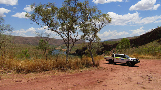
We're in the Kimberley. It's about 10.30 in the morning and the temperature is about 43 degrees. The air is bone dry — none of the Darwin humidity that we've got used to. We have just driven through a river crossing and up a steep, scrabbly, gritty, dusty 4WD track to this viewpoint across the Pentecost River.
The Kimberley is the north-eastern region of Western Australia. We're travelling within the circled area.


Hot and dry as it is, the Kimberley has lots of water. Big rivers! About 50 years ago, the Ord River was dammed and two lakes — Lake Kununurra and Lake Argyle — were born. Lake Argyle is now Australia's largest freshwater lake.
Kununurra is a town about 30 km west of the NT border, about 10 hours by road or one hour by air from Darwin. We flew. Kununurra was created as a town to house construction workers when the dams were built. It still has a very small population of about 4,000.
From Lake Kununurra, we did a six-hour return boat trip through the original Ord River-course to Lake Argyle. My sinuses can attest to the fact that it was quite a speedy boat trip, with plenty of wind and water spray all the way.


We stopped for a swim, and for afternoon tea on the river bank, and there was the glorious Kimberley sunset to enjoy as we came home. Plentiful bird life, lots of fish, no saltwater crocs, only the shy little freshwater crocs that eat lizards and frogs and insects and fish. Can you spot the very pretty freshie sunbathing on a convenient rock?


The Kimberley landscape is very distinctive. It's a land of stark geological features — crags, cliffs, weathered rocks, ancient seabeds and active faults. The Mirima National Park on the outskirts of Kununurra is a great place for a walk and a climb along the top path, early in the morning. Very early in the morning. By 10.30 am, all one can do is swelter by the pool.


Did you notice the striped conical hills? Multiply that a few hundred times and you have the glorious Bungles Bungles, all 500 sq km of them.
The Bungle Bungle Ranges is a UNESCO World Heritage-listed site in the Purnululu National Park, about 200 km south of Kununurra. The Bungles are like giant, striped, rocky beehives. The rock itself is sandstone and conglomerate, quite light in colour, but some 'stripes' hold more moisture and so plant bacteria grow on those layers. Those layers look darker than the less porous rocks; the orange stripes are rock that contains iron.


Who wouldn't want to see rock formations with a name like the Bungle Bungles?
Fascinating geography en route, and even a very ancient meteor crater called the Piccaninny Crater — not very PC, but obviously it's considered a little 'un.


The flight path from Kununurra to the Bungles is over Lake Kununurra and Lake Argyle, and over the irrigation channel which was the impetus for the whole scheme. We also flew over the Argyle Diamond Mine (of pink diamonds fame), which closed a few years ago.


There's about 150 sq km of land under irrigation. Crops include sandalwood (very lucrative), vegetables, chickpeas, chia, mangoes and other tropical fruits. There was an attempt to grow rice to export to Asia but the magpie geese ate the shoots faster than they could grow. So no rice. Cotton has been tried, but the local insects dined out on them too. So the general sense is that it's a grand scheme, but an underutilised one.
Which takes us now to Lake Argyle, which has a surface area of about 1000 sq km. Depending on the time of year (wet or dry), its water capacity is anything from 12 times to 21 times the size of Sydney Harbour. It releases enough water in one day to cater for the populations of Adelaide and Perth for a year. But the tyranny of distance means that it's used only in the sparsely populated north for irrigation and hydro power. It supplied all the power to the diamond mine when that was still operational; now, there's power and water to spare — not a common situation in Australia (or anywhere, really).


The story of the Lake Argyle dam wall is interesting. It cost a piddling $26 million to build because it's earth-fill, there's no concrete in the dam and only local materials were used. It's the most efficient dam in Australia in terms of the ratio of the size of the dam wall to the amount of water stored. Here's the dam wall from the air, from the wall itself, and from the boat on the river.


About 70 km from Kununurra by sealed road — yes, that's relevant — is the Lake Argyle resort. You can see the resort in the aerial shot: the small group of buildings at 12 o'clock to the wall. The resort has a legendary infinity pool that has been judged amongst the world's top 10 Instagrammable pools. (It's a thing, apparently.)


Yep, the pool is pretty but there were other places to swim that were more interesting. Reaching the pontoon in Pannikin Bay was a bit of a strenuous hike but there's nothing like vigorous exercise in high temperatures to make you appreciate a swim.


When at Lake Argyle, do the sunset cruise. It's a 20 to 30 km cruise, stopping a few times along the way. The shy little short-eared rock wallabies can be enticed out of their crevices to hop down for some horse pellets. They've adapted to these steep rocky slopes to escape their predators — pythons and dingoes are far less nimble than they are on these sheer cliffs. They look a bit untidy at this time of the year but that's because they're losing their winter (hah!) coats.


Another stop on the lake is to feed the archer fish. Archer fish spit at insects flying above the water, which then drop into the water for them to eat. Our instructions were to hold the bread fragments above the water and not to drop anything until we were spat at. I was spat at a lot. The science of archer fish spitting uber-blobs of water is worth a read: https://www.wired.com/2013/11/archerfish-physics/. Anyway, this spittery-spattery / uber-blobbery attracted a little freshie, who has clearly learned that a mob of fish gathered in one spot represents an easy meal.


We also stopped for two swims in the lake, the second about 20 minutes before sunset. I can recommend floating in a lake with a glass of bubbles (me) or a beer (Ken), and a floating tray of snacks, watching the sun go down.


On to El Questro station, via the Gibb River Road. El Questro is accessible only by 4WD, so we swapped our comfortable hire car for a more utilitarian vehicle. The 20 km track to EQ is unsealed, with water crossings of the Pentecost River. It's an adventure. I thought it would be way more exciting if I opened the car door while I was filming but spoilsport Ken forbade it.


El Questro has a number of springs in the many gorges on the station. Zebedee Springs is a thermal spring: the water temperature stays at a warm 30 degrees all year round. Do you remember the nibbly fish in the swimming holes at Berry Springs? Well, here we were nibbled by tadpoles. Many many tadpoles. And it was important to check all parts of one's swimsuit before leaving the water, to ensure that tadpoles stayed in the water and didn't come home with us.


Other than tadpoles, El Questro has a resident donkey called Jilly, seen here in front of our cabin (most fittingly, we were in a cabin called Archer Fish). I thought the rooster recently in our care was loud, but a donkey braying at sunrise is far, far worse. Lots of frogs everywhere (and sadly, cane toads) and flocks of blue-eyed cockatoos.


The Kimberley is the land of the boab. But is a boab the same thing as a baobab? Yes and no. They're part of the same genus — but there are six species: four of them in Madagascar, one on mainland Africa and one in Australia. The Australian species grows only in tropical Western Australia and Northern Territory. They're as distinctive a part of the Kimberley landscape as the geological forms and rivers.


I think the Kimberley boabs may be my new favourite tree.


OMW Jules! Freshies, spitting fish, tadpoles, toads, donkeys and wallabies at 44 degrees! Thank goodness for the swims and champers 😉